MWI’s Automatic Location Tracking System (ALTS) solution is based on GPS technology to track vehicles, personnel or any asset that has an in-built GPS receiver and has the means to communicate its position to a backend system. The solution is feature rich and highly scalable.
Features a light-weight web based scalable solution that can be deployed on the intranet or internet environment to track hundreds or thousands of devices.
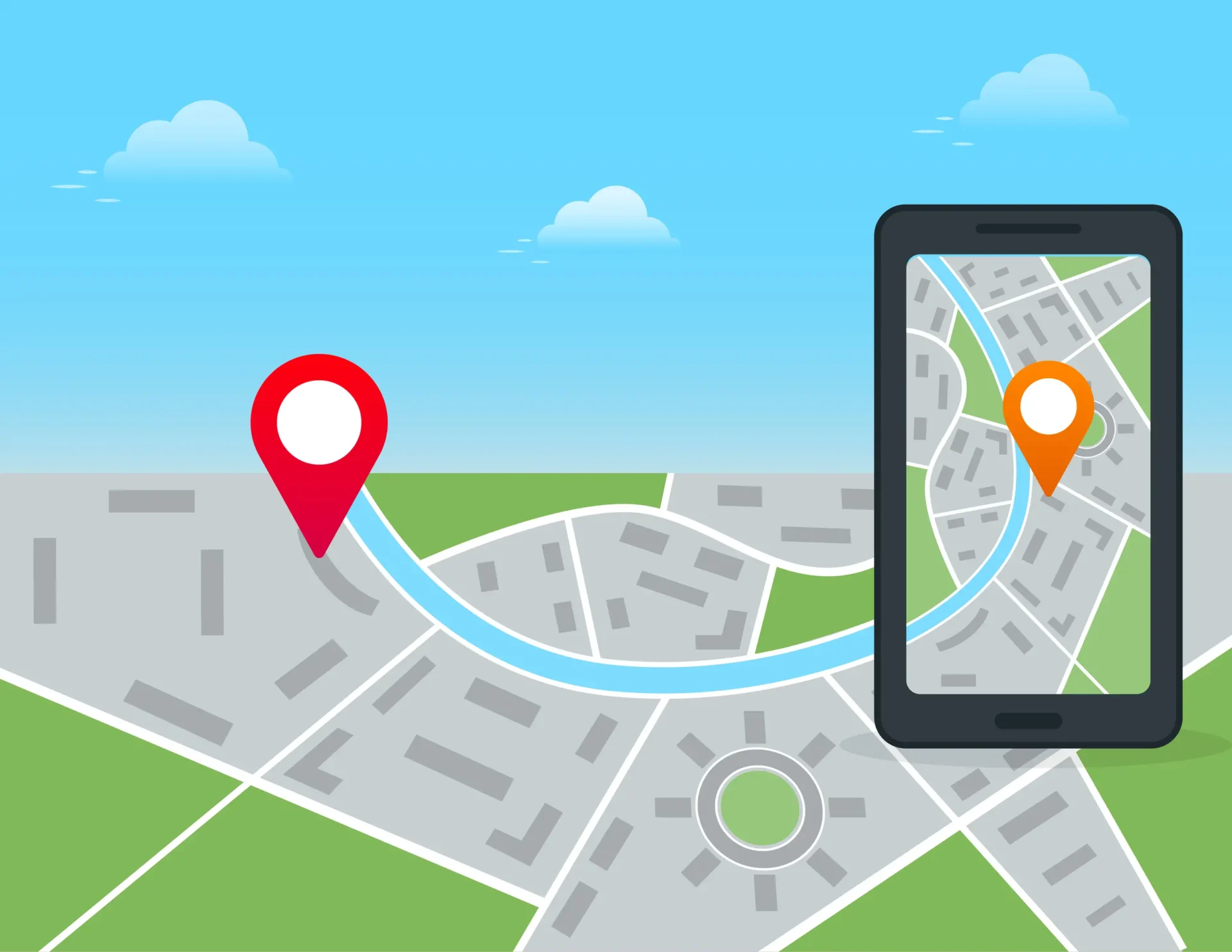
The software provides a map-based view to display the real-time tracks of a single device or a group of devices as defined by the customer.
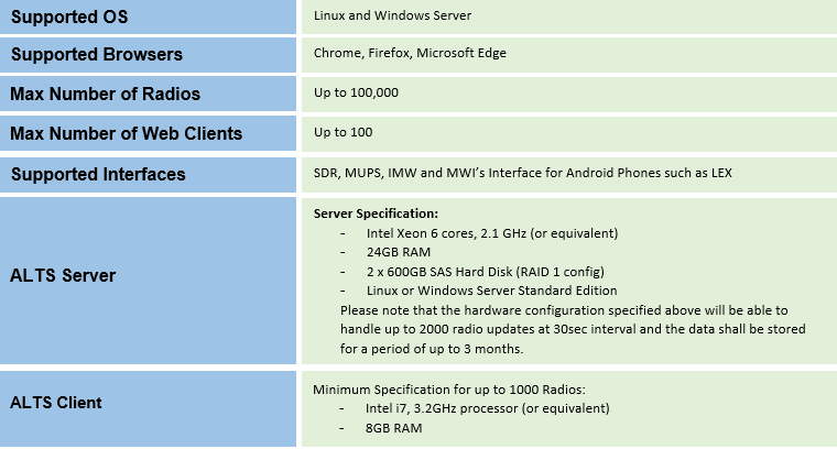
ALTS system has been successfully deployed on several Dimetra & ASTRO infrastructure in the Asian region. It can support GPS updates from TETRA / ASTRO radios, LEX and other Android based phones.
Group Map
- Track movement of selected radio groups in real-time.
- Auto Update on/off
- Standard MAP features – Pan/zoom map, re-center map, show device details, distance calculator, etc.
- Specify icons for each group
- Show Geozones
- Location details in tabular form
Device Map
- Track the movement of selected device / vehicle in real time.
- Auto Update on/off
- Standard MAP features – Pan/zoom map, re-centre map, show device details, distance calculator, etc.
- Replay archived GPS positions
- Show Geozones
- Location details in tabular form
Ad-hoc Command to Device
- From group map & device map, user can select an ad-hoc command to send to the device. Depends on whether customer server can support ad-hoc commands.
Reports
- Device Event Detail Report;
- Group Event Detail Report
- Group Last Location Summary Report.
Geo-fencing
- Geozones being created to track radios inside/outside geozones, or to generate geo-fencing alerts based on geozones.
- ALTS system supports Point Radius & Polygon geozones, which can have up to 20 vertices.
Composite Geo-fencing alert rules can be created with combination of multiple geozones
Account Admin
- Represents a customer/organization.
- An ALTS system can be shared by multiple customers/accounts.
- Each account can be configured with distinct account logo, time-zone, metric system, GPS format, device/group label etc.
Device & Group Admin
- Device can be configured manually in ALTS System or imported from exported UCS data in CSV format (for Motorola Radios).
- Device Group definition allows for monitoring of radios as a group, radio groups are created according to functions of organizations, the system can assign radio groups to users so that users can track only assigned radio groups.
Language Support
- English
Supported Maps
- ESRI Shape files, Geotiff files,
- Geo database & PostGIS database
(Note: Motorola shall supply the maps for MWI to format & load into MWI’s MAP Server)
- Openstreet Map (Online Map)
- Google Map (Online Map)
(Note: Motorola shall buy Google API key for Google MAP Service usage)
Basic & Run Time Alerts
- Speed alert – thresholds can be defined.
- Emergency alert – emergency button/man down is triggered.
- Comms Failure – no updates for designated time frame.
- Provides ability for a user to monitor device/vehicle alerts which shall be updated in near real-time whenever system triggers an alert.
- User can acknowledge/close active alerts on this page.
Historical Alert Page
- Provides ability for a user to search alert history based on:
- Device/Vehicle group;
- Vehicle;
- Alert status;
- Priority;
- Alert Type;
- Acknowledged user;
- From Date & To Date;
- Reports can be generated for historical alerts.
Geozone Admin
- This feature allows creation, editing and deletion of geographical fences (geozone) on the map display.
Geo-fence Alerts
- Inside/Outside Geozone, Entry/Exit Geozone alerts.
User & Role Admin
- Roles can be created for grouping of access rights; a user configured under a role will inherit the access rights from the role.
- Access rights are assigned to different users to access different resources in the system, including functions, and information pertaining to device group.
Alert Rule Admin
- Alerts are triggered based on alert rules; alert rules can be configured according to different criteria such as position, speed, date time, device groups etc.
Vehicle/Personnel Admin
- Devices can be associated with a vehicle (or) person. Tracking and reporting can then be done based on vehicles/persons.
Additional Language Support
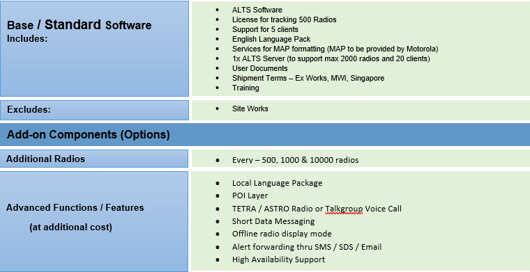
- Spanish, French, German, Greek, Italian, Dutch, Hungarian, Portuguese, Romanian, Russian, Serbian, Turkish, Japanese, Chinese, Thai, Indonesian.
Point-of-Interest (POI)
- To add wayside points in database so that they can be displayed on Map.
High Availability Support
- To cater to high availability, the solution will be deployed with load balancing and DB replication.
Voice Call & Messaging
- From group map & device map, user can select a Radio and make a voice call or send Short Data Message to devices.
Alert Forwarding
- Alert rules can be configured with Notifications. ALTS supports 3 types of notifications – SMS, Email and SDTS message.
Offline Radio Display
- There are 3 modes: Last Location (default), Hide and Grey Out. User can configure offline radio display mode in account settings
FAQ
Yes, Gateway need power supply.
If there is a loss of power supply for gateway, the gateway stores the data locally and once the power is back, the data will be uploaded.
No data will ever be missed.
Yes, It is affordable as per Indian market standards.
Yes, Tech support – remotely will be available.
Installation cost on-site will be an extra added service.
Blogs
-
ACG Groups, Mumbai:
Domain: Pharmaceutical Company
MWI was fortunate enough to get hands on experience with on the the biggest pharmaceutical company who are great manufactures of medicinal products.
Link: https://www.acg-world.com/
